
The below are the 3 main routes up Mount Kenya. However, we can mix and match the itineraries up. You can go up Chogora, come down Sirimon, go up Naro Moru, come down through Chogoria, or tell us what you want and we will be at your service!
The Sirimon Route
The Sirimon route is one of the easily accessible routes and an enjoyable one. It is on the drier side of the mountain. The route starts on the north west side of the mountain near Nanyuki town. Day 1 takes you from Sirimon Gate to Old Moses Camp (also known as judmier Camp) which is at an altitude of 3,300m ASL. From the gate, the track is an uphill that takes you through the forest which becomes heath land after about 3 hours. It veers right through to Old Moses Camp. On Day 2, after walking for approximately one hour, the track crosses Ontulili River. You contour through the moorland and cross the Liki north and continue uphill to Mackinders Vallley. Enjoy the panoramic views of the valley as well as the main peaks if weather conditions are favorable. You will also see giant Lobelia and Groundsel which are the classic Mt Kenya flora. You move on to Shipton’s Camp which is at 4,200m ASL. Day 3 maybe the longest day of the trek but the most fulfilling one! You start the trek early at 2am to aim to reach Point Lenana (3rdhighest peak of Mt Kenya) at sunrise. You walk up a stony quarry that cuts through a cliff clearing, overlooking the Halls Tarns. From the summit, you can see the majestic Nelion peak, usually sun kissed during sunrise. Many tarns can also be seen from the summit. After achieving the goal of summiting, walk down to Shiptons, have breakfast, and move on to Old Moses for an overnight stay. The last day of the hike is usually of mixed feelings. You want the comfort of your bed and also sad to leave the mountain. You walk down to the gate and get transferred to destination of your choice.
The Naromoru Route
This route is accessed from the West of the mountain. The trek starts from the Naro Moru Gate. Keep to the park track, walking through the forest. It is a pleasant walk to Meteorological Station. As you walk further up, you get good views of the Northern Naro Moru Valley on the left. The trek ends at 3000m. On the second day, set off through the forest and enter the moorland. Expect bog, from damp to glutinous conditions, depending on when it rained last. Continue through until the going improves and you reach a fork overlooking Teleki Valley to reach Mackinders Camp, 4,200m. On a good day, you will be able ot see the majestic peaks – Batian, Nelion, Point John, and Lenana peeping from the back. Moving on to Day 3, it is a very adrenaline filled, long day. We start as early as 2am for the summit push. We walk up a steep scree, pass by Austrian Hut, and take a half to one hour trek to Point Lenana. Enjoy the panoramic views from atop. Descend down to Mackinders Hut for breakfast, and then move on to Met Station for overnight. On Day 4, walk all the way down to the park gate.
The Chogoria Route
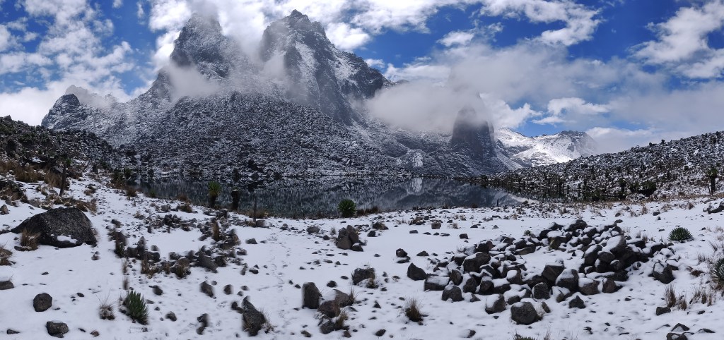
This is one of the most scenic and rewarding routes on Mt Kenya with beautiful landscapes and the exotic flora. This route is from the East side of the mountain. On the first day, you are driven to Chogoria town, and to Chogoria gate, where you will spend the night in high altitude tents or if you are looking for comfort then you can stay at the Meru bandas at an extra cost. The trek starts on Day 2, whereby you will head to Minto’s Campsite. It is a fairly long trek, with chances of sighting elephants, buffalos, impalas and bush bucks. You walk through a forest, then through the heather, cross the Nithi river and on to the moorland. Here you will get beautiful views of the Gorges Valley, Temple Lakes, mushroom rocks, Giant Billiards, and the high peaks. Day 3 is the summit hike day! You start the day as early as 2 am to reach the summit, Point Lenana, to witness the African Sunrise. Straight after, you start the descent back to Minto, have breakfast, and walk on to the gate. It is a long day but definitely a rewarding one! On the 4th day, you have to say goodbye to the mountain as you go back to civilization.
The Hidden Gems of Mt. Kenya Adventure
It was a cold Thursday morning when the Bootstrap Adventures team set off for the Mt. Kenya Naromoru Park Gate (2600m). The strict COVID-19 measures implemented by KWS for all visitors were handled very professionally and in no time, we were allowed entry into Mt. Kenya National Park after payment of our park fees. We drove up to Met Station (3050m) where we parked our vehicle and set off for the epic climb that had been delayed by a few months’.
The trek takes you through the forest and into the Alpine heath, leading you over a small wooden bridge which leads to the Teleki valley, where you walk over once you cross over a small wooden bridge which is above the a freshwater stream flowing from the majestic snowcapped Mt. Kenya. The Tteleki valley welcomes you with gorgeous views of the peaks, taking you and it leads to Mackinder’s Camp (4200m). This is where we will be spending the night, a basic banda with bunk beds owned by the Naromoru River Lodge. The dining area showcasesis continuously facing the Mt. Kenya peaks, of Mt. Kenya which is soa magical dining experience at any time of day. The cold, crisp, sweet and fresh water directly from the mountain is an experience in itself. fascinating thing about being on Mt. Kenya is the crisp cold sweet fresh water that you directly get from the mountain.
We spent the night in a basic banda with bunk beds owned by the Naromoru River Lodge. Sleeping through It was aa stormy night, and we awoke the next morning to picturesque white, snow capped peaks to which pictures do no justice. This unparalleled viewThis kick really kicked off our started the Friday feeling, compounded by and a much awaited hike around the peaks circuit: which was going to be full of breath-taking scenery.
The trek began withwas an immediate steep ascent of snow to Two Ttarn (Hut tarn and Nanyuki Tarn) 4490m located on Tteleki Rridge. The weather was perfect, the clear skies brought to usas the majestic peaks of Batian (5199m), Nelion (5188m), Point Lenana (4985m), Point John (4883m) were so clearly visible and reflecting on the Hut Tarn. We also spotted Diamond Couloir and Gate of Mist could be spotted too. As we moved further along Emerald Tarn (4450m) located along the western peak circuit between Nanyuki tarn and Arthur’s seat, its beauty did not disappoint. were not to be missed showing their beauty.
The terrain into the Western terminal going into the Hausburg Valley, usually quite rocky, filled with was now full of rocks and bou boulders. Due to the overnight storm, early morning ice had formed, keeping the terrain and ice it was quite slippery, which made the trek tricky but thrilling and the ever changing views were equally delightfulviews kept changing with every step.
Stepping Upon stepping foot into Hausburg valley we were welcomed by Hausburg Tarn (4370m), definitely such a stunning sight to behold, beside the and next to it is the Oblong Tarn (4370m) located on the Hausburg valley whichand is closer to Point Peter (4757m) and Point Piggot (4957m) and, Point Dutton (4885m) peaks. A rock in between the two tarns provided was a perfect lunch set up, for lunch with a roaring steep scree facing our next attempt to reach Hausburg Col which bringsgetting us to Mackinder Valley. The scree wasIt was a harsh and rocky scree to start off with, eventually leading to an icy, loose rocks zig zag loose rock scree fromafter which where Shipton’s Camp (4250m) was finally visible. Shipton’s camp would be our rest point for this evening.
The weather had been kind to us, with the thinner and crispier air getting thinner, crisp and was colder but that did not deter us from carrying on. The peaks We were surrounded by peaks which looked so close enough to touch, tempting you to continue your exploration yet so far away but definitely tempting your mind to make an attempt to conquer themit.
Shipton’s Camp is the amore popular place for Mt. Kenya trekkers on Mt. Kenya and is owned by Mountain Rock Lodge. It which has bund beds, indoor cabin washrooms inside the cabins, with well insulated walls and the cabins are fabricated well to keep the guests warm. An early dinner was later followed Dinner was eaten early followed bby some clear and starry night pictures, a positive sign of the stars on a clear sky which had us all puzzled in readiness for our summit plans push early that early SatSaturday morning. We retired for the night after discussing all possible weather outcomes, certain in the knowledge that All pros and cons of weather were discussed in detail but eventually we retired for the night on the conclusion come rain or storm the summit push is on schedule. The heavens opened that night, and we woke up, realizing we to the thoughts of trekking would continue in harsh rainy and windy conditions in order to summit Point Lenana.
We had aAfter a quick early breakfast weand set off towards Simba col, where and a surprise eagerly awaited us. The weather changed in our favor and it was a pleasant and warm trek up past Square Tarn 4700m located at the start of Gorges valley. The terrain began with rocky, loose soil in the start was quite rocky with loose soil on a very steep incline, eventually changing to rocks sand snow. Our heartbeats intensified as we climbed highergot intense with every step that we climbed, and while the sun slowly started risingrose as we got closer to the summit. We were treated to a beautiful sunrise, lightingThe skies changed colors to one of the most beautiful sunrise that you could ever imagine to see. As the sun rose it lit up Nelion to an amazing orange color which was out of this worldin its fiery light. The final few steps to the summit arrived, with and the terrain got getting trickier. The with the cable line was submerged under snow, forcing us to carefully maneuver our steps to the mounted ladder, climbing onto and then came the mounted ladder which led us to reaching Point Lenana (4985m). What an indescribable feeling!!! The blessed sun bathed us with warmth, energy and probably some great vitamins too! shone on us with its blessings, warmth, energy and possibly some vitamins too!! The Kenyan flag mounted on Point Lenana with its congratulatory message board gaveiving our mobile phone cameras an opportunity to capture our achievements, freezing and moments in time foreverthat will remain forever for years’ to come. The 360-degree view from Point Lenana is spectacular, and the hovering clouds hoovering below making it even more magical. What an unbeatable view!! We also spotted Gallery Tarn, Lake Alice and Lake Michaelson which are in the Hobley Valley from our Point Lenana viewpoint also gave us views of Gallery Tarn, Lake Alice and Lake Michaelson which are in the Hobley Valley.
After spending a good 15 minutes absorbing the sights, sounds and smells, off we went on ourwe were now off to descent back to Mackinder’s camp via the Austrian Hut. Unfortunately, we were to face but there was an unknown obstacle that stood in our way. The stormy night rain / storm of the night before had made the descent impossible and dangerous. and Tthe guide was quick to enforce his authority, and informing us that we should go back down the same way we came up, and then and go round Point Lenana where the cChogoria route meets Austrian Hut.
As we descended down the ladder from Point Lenana, Curling Pond with its ice cave was visible, its pond and this incredible pond was of a much larger size than it was a few years backago. Clear signs of global warming and its effects on our environment which sadly the future generations may never get to see!
We carried on down past Square Tarn towards tTooth, and the route was full of huge slippery rocks and boulders, making which made the hike harder and energy draining. At this point, focus it was very crucial, as it was important to remain focused and to take each step with utmost care. The steep scree up the Hhobbley Vvalley towards Austrian Hut (4790m) was mentally challenging. We eventually arrived at Austrian Hut to a much-neededmuch needed resting point, needing to recover from the strenuous, treacherous hike to boost up on our energy levels. The hut was empty, and the weather becoming cold and misty once again. We were quickly back on our feet and down the slippery scree of Teleki valley for our quick scheduled lunch stop at Mackinder’s camp. Enroute our descent we saw Lewis Tarn (4800m) located below the Lewis glacier which was a massive glacier several years back, and definitely shows signs of melting.
After aThe quick lunch at Mackinder’s Camp, we realized that was quick and we were exhausted, exhaustion was quickly kicking in now, but some energy boosters pumped primed our bodies back into action for the quick descent down to Met station. The weather held up, however, the rains from the previous nights’ had made the terrain in the Alpine Heath quite mushy; we had to splash our way through water and bog, realizing that and as Naromoru is known accurately known as thefor Bog this is exactly what we had to walk through which made it more challenging but fun splashing through water and bog. As the light of the setting sun filtered through,As the sun started setting, we approached the forest and finally on the last stretch of tarmac path to mMet station where we would rest for the night, our conclusion to and conclude the end of this phaseour of adventure.
We drove back downThe next morning was our drive back down to the Naromoru Park Gate the next morning, off and on tto Nairobi and back to reality and civilization with Mountain blues to follow!!
At Bootstrap Adventures we can plan your trekking requirements to your specifications. as above or anything adventure that you may have in mind. Kindly get in touch with us here.
